News
Seeing the full story behind every landscape
Recent improvements to LandScale Profiles make it easier to explore, manage, and understand landscape information. An interactive map enabled through the explorer.land integration with OpenForests, goals that can be synchronized from Landscape Initiative Maturity (LIM), improved boundary management, and stakeholder details now housed in the About section together create a clearer and more intuitive Profile experience.
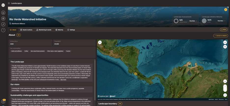
What’s new in LandScale Profiles
A landscape is more than a boundary on a map. Understanding it also means being able to explore its wider environmental context, understand what an initiative is working toward, and see who is involved in making that work happen.
That idea sits at the center of the latest improvements to LandScale Profiles. Each update enhances a different part of the user experience. Together, they make Profiles easier to manage, explore and keep current.
LandScale Profiles now include an interactive map through an integration with explorer.land, a platform built by OpenForests. The map allows users to explore a landscape boundary alongside a growing range of global geospatial data layers, providing additional environmental context around the landscape.
The integration also incorporates ESRI Wayback imagery, allowing users to explore historical satellite imagery and see how the wider area has changed over time. These capabilities provide additional spatial context that can help users better understand the setting in which LandScale assessment information is presented.
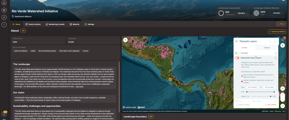
Three further improvements complement the mapping integration.
First, goals defined through Landscape Initiative Maturity (LIM) can now also appear in the Goals & Actions section of the Profile, reducing the need to enter the same information twice and making it easier to keep goals current. Clearer empty states also help users identify when information has not yet been added.
Second, landscape owners can now copy and synchronize boundary information between Profiles and LIM, helping maintain consistency across both parts of the platform.
Third, stakeholder information has moved into the About section, placing information about the organizations and actors involved in an initiative alongside other essential information about the landscape.
Together, these updates help Profiles answer important questions more intuitively: Where is the landscape? What is the initiative working toward? Who is involved? And what information is available to help understand its wider context?
The result is a more complete and accessible Profile experience for landscape initiatives and for businesses, investors and other stakeholders seeking to understand their work.
Building toward more transparent, connected landscape information
These changes reflect LandScale’s continued effort to make landscape-level sustainability information easier to access, understand and use.
The explorer.land integration adds a richer visual and spatial dimension to Profiles, allowing users to explore global geospatial layers and historical imagery alongside the other information available on a landscape Profile. Rather than directly connecting these data layers to LandScale assessment results, the integration provides additional context that users can draw on when exploring a landscape and its assessment information.
At the same time, improvements to goals, boundaries and stakeholder information reduce friction in keeping Profiles accurate and up to date. LandScale’s assessment framework continues to provide the structured evidence for understanding sustainability performance across the landscape.
Together, these improvements strengthen Profiles as more than a place to present assessment results. They provide a clearer window into a landscape — its geography, sustainability conditions, stakeholders and ambitions — while making key information easier to find and manage.
For landscape initiatives, this means an easier way to communicate their work and maintain key information. For businesses, investors and other stakeholders, it provides a more intuitive way to explore landscape information and understand the context in which initiatives are working to address sustainability challenges.
Log in to explore the updated Profile experience, or reach out to the LandScale team to learn how these tools can support your landscape’s reporting and engagement goals.